William Laval Miller: 1905 Mapmaker
The profession of civil engineering was honored early in South Carolina history. Before the Civil War the state invested heavily in canals and railroads. During the 1830s it boasted the world’s longest rail line, for example, with an innovative “inclined plane” to winch trains over the granite summit at Aiken. Not far from Tryon remains impressive Poinsett Bridge constructed in 1820, on the State Road built to high standard as a tollway, to Saluda Gap on the North Carolina state line. Such ambitious projects required well-trained engineers, including “topographers” who specialize in land reconnaissance and sophisticated mapmaking.
William Laval Miller was born in Charleston in 1860 and named after Captain William Laval, who was involved in the 1820s project to construct Fort Sumter on an artificial island (70,000 tons of granite were brought from New England to build it) in the harbor. His father Lovick Pierce Miller served as a Confederate cavalry officer.
Bench Marks
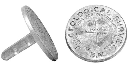
In 1879 the U.S. Geological Survey was founded in Washington. In 1881 John Wesley Powell became its director. A restless explorer from a poor family, Powell’s ambition was to make his agency an important force for bettering the nation. He appointed Henry Gannett (1846 – 1914) to establish a professional topographic mapping bureau in 1882. Harvard-trained geographer and administrator, Gannett accomplished all kinds of innovations during his 14 years heading the bureau. He initiated the standardized field Bench Mark, and convinced even the railroads to deploy standard datums so that data from all survey sources would connect. He authored many publications intelligently written for non-technical readers. In 1888 Gannett was one of the founders of National Geographic Society and he was a founder, as well, of Washington’s prestigious Cosmos Club for men of science.

Henry Gannett, Miller’s mentor
author of 1893 Manual of Topographic Methods
published by United States Geological Survey
Updated in 1906, Gannett’s manual tells us
how Miller’s crew conducted the field survey and
illustrates equipment they used to make the map.
At that time many talented young Southern men were struggling. In 1876 William’s grandfather, a Methodist evangelist, was murdered in rural South Carolina by a black ruffian who robbed him at gunpoint. The crime was widely publicized during that era of enormous racial tension and political upheaval. William’s father separated from his mother — who migrated to Georgia — and remarried a much-younger woman, six years older than the son, and moved to Florida. So like many “rootless” but young men in their twenties from the former Confederacy, William Laval Miller found a position in Federal Service in Washington. He went to work for Gannett in 1885 and remained employed in the Topographic branch his entire career.
It was Miller’s good fortune to work for “the father of mapmaking in America.” In turn Henry Gannett trained his recruit well. The young Southerner was sent around the nation on increasingly important assignments. He accomplished them systematically and thoroughly. William never married, never owned property, and was Gannett’s trusted lieutenant to execute the Topographic branch’s mission in regions that had never been professionally mapped before.

Topographers worked winters in the Hooe Building, the first in Washington of iron construction. Fires were a constant jeopardy to destroy months of field notes and map manuscripts in-process. Indeed a disastrous 1913 fire at the Hooe incinerated significant holdings of valuable papers.
In 1897 topographer Miller was in charge of a party to survey Western North Carolina in Madison, Haywood, Burke and Caldwell counties covering 848 square miles, along with mountainous territory in Cocke county, Tennessee. Nine permanent Bench Marks were placed and 92 miles of spirit levels run in a bit over four months. He then was transferred to field work in Georgia, and returned to Alabama where he surveyed in 1889 – with agency geographer H.M. Wilson, the same colleague with whom he was to collaborate on Polk County work in 1905. In late 1899 he completed field engineering in Buncombe county for a new quadrangle. From there he returned to Washington for winter work at Branch headquarters for review of his copious field data and sketches, before a new spring-season assignment out to mountainous western Pennsylvania.

In 1903 USGS got its own flag, the blue ensign. Orders came out from Washington “It is hereby directed that chiefs of all Survey camping parties shall fly the United States flag and the Survey ensign from their camps at all times.” Topographers on field duty wore a special Survey coat button too. Thus Miller’s crew were distinctly visible, under protection of Federal law, who could enter private properties for official purpose.
Miller would reside in boarding houses while he did his work. In the 1900 census we find him living in one at East Brady in the sparsely-populated “Pennsylvania wilds” on Allegheny River. He was 39. Assisting him on this assignment was boarder W.H. Maxwell, 27-year-old civil engineer from Pennsylvania. Their work that summer resulted in a typical USGS map crediting Miller, carefully reviewed by professional colleagues back in Washington the next year, engraved and released in January 1902. The depicted steep terrain is at least as challenging as what Miller tackled in Polk County, North Carolina.

During World War I the Army welcomed all the experienced topographers they could get. Younger men went to service overseas, while the older worked on the home front. Miller was commissioned Captain mapping in Illinois, where he had earlier experience in areas important for strategic minerals.
His field assignments in autumn 1904 and for spring 1905 were to Kentucky. In 1905 Polk County News reports W.L. Miller will start his local work for its US Geological Survey. We don’t know who worked with him. It was a relatively easy assignment topographically. By now he had 20 years experience doing the field work. About that time his father, the old Confederate cavalryman, relocated to Newberry county in South Carolina, to farm. The stepmother was fifty, they had a teenage son and daughter. A trip by train down to Newberry was easy from Tryon depot, and Miller’s government assignment included territory almost as far south in South Carolina as Spartanburg. One supposes any family wounds had by now healed. Miller was buried at the same Newberry cemetery as they, when he passed away at Augusta, Georgia in 1937.

1905 Dumpy Level
Miller was with the bureau in Washington D.C. when USGS devised a new way to map roads accurately using a “wheelbarrow” that only slightly resembled its common namesake. It was a lighter, larger wheel with perimeter one half of a surveyor’s rod-length, with tire and axle bearings of brass. An odometer recorded revolutions of the wheel. A sight compass was mounted on a staff to attain vertical position when the rig was stationary on its two legs, which carried a box for notebook, canteen and lunch. Bearings of foresights and backsights along the road were read on the compass; corresponding distances were recorded from the odometer – both in the notebook so that the traverses could be plotted at night, or when weather prevented work out-of-doors.
Superior to the Wye levels used by 19th century land surveyors, USGS topographers used Dumpy levels with fewer moving parts to record thousands of observations required for precise contour work.
1905 Topo Map of Tryon Peak and Columbus
William Laval Miller's 1905 Topo Map of Tryon vicinity
Click here for information on Miller's 1905 Topo Map of Tryon vicinity.